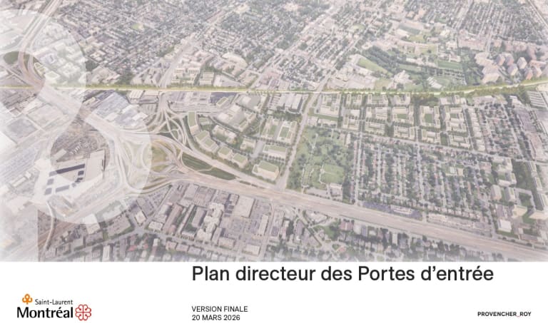
Accessing Saint-Laurent from the South: A New Vision
Several major corridors, or gateways, provide access to Saint‑Laurent from the south. The Borough of Saint‑Laurent presents a long‑term vision to gradually transform this area into greener, safer, complete neighbourhoods with local retail services.
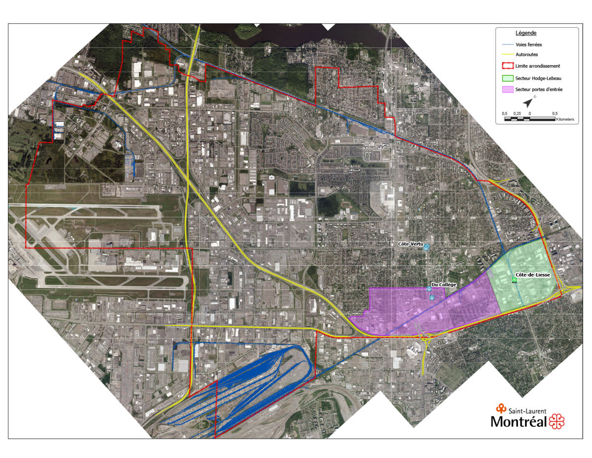
Saint-Laurent’s municipal administration has created a master plan for the development of the southern part of its territory around the Décarie Interchange (Décarie Circle).
The plan proposes a medium- to long-term vision centred on the daily needs of residents: walking safely, accessing the metro more easily, finding shops and services close to home, and enjoying high-quality green spaces.
These changes will be implemented in phases over the long term, leading up to 2050.
This page will be updated regularly to highlight the milestones achieved as they occur.
Why this plan?
The southern part of Saint-Laurent serves as a major “gateway” to the borough. It is accessible via Alexis Nihon, Marcel Laurin and Décarie boulevards as well as via Avenue Sainte-Croix. As part of Saint-Laurent’s 2026–2029 strategic planning, this plan aims to gradually redevelop industrial and commercial sites in order to create complete neighbourhoods: safer and greener streets, easier walking and cycling routes, and more local shops and services.
What does this new vision propose?
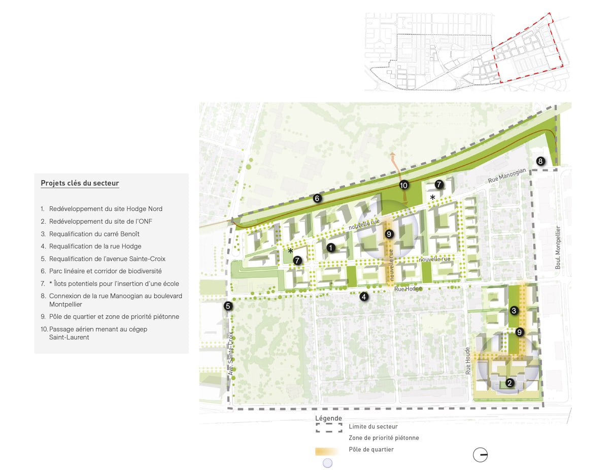
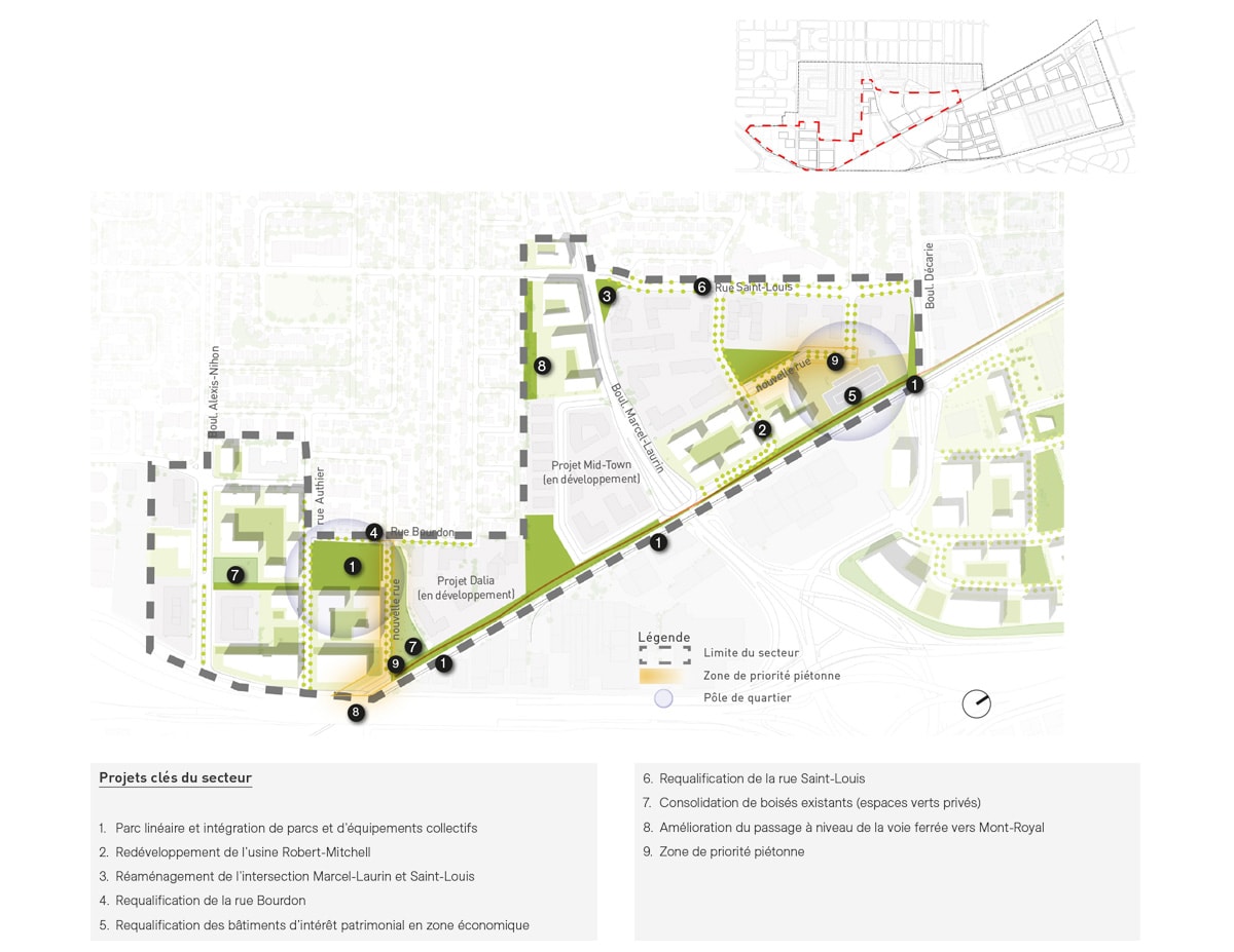
- A large linear park along the railroad tracks: an active route (for walking and cycling) that will connect several sub-sectors while promoting biodiversity. This is the green “backbone” of the area.
- More accessible green spaces: up to 160,000 m² (parks, biodiversity areas and recreational areas) to reduce heat islands, better manage stormwater, and limit nuisances from the autoroute and railroad tracks
- Convenient local services and shops in the right locations, with attractive ground floors (grocery store, pharmacy, neighbourhood restaurants and a new school)
- Safe, continuous bike paths, including a new railway crossing north of Rue Manoogian to better connect the east and the west
- Friendly, green streets: widening and improving sidewalk safety, landscaping and street furniture
- A prestigious business district along the autoroute to encourage job creation and enhance the area’s gateway image (landmark buildings), while phasing out industrial uses and the associated trucking traffic
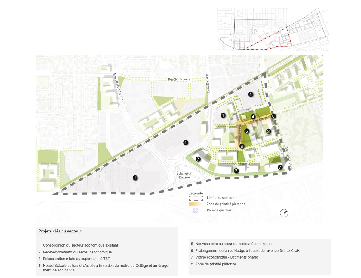
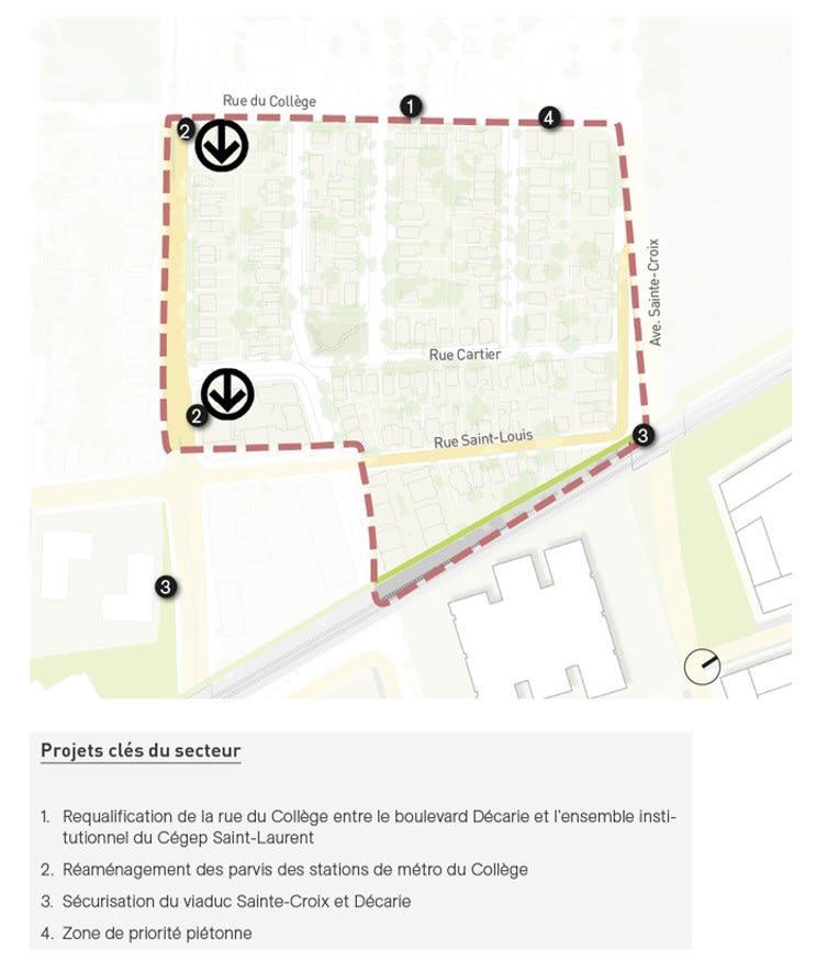
Improved access to the Du Collège metro, through a new entrance shelter south of the railroad tracks and the redevelopment of the front area of the metro station, for getting around faster and more comfortably.
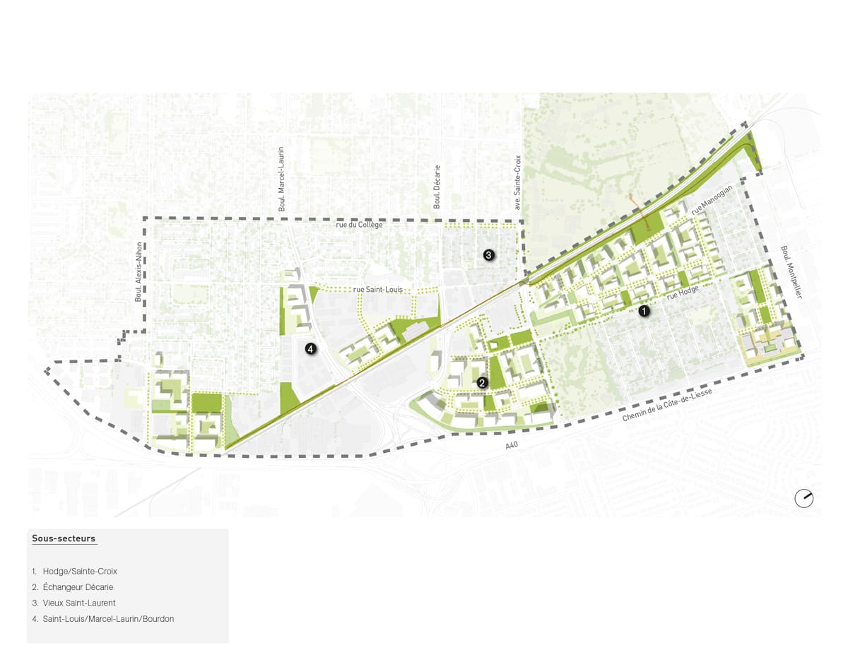
Where is this happening?
What concrete changes will you see in your daily life?
- On foot or by bike: direct, shaded and safe routes to school, the metro, shops or parks
- With a stroller or in a wheelchair: more comfortable sidewalks and better-protected crosswalks
- For families: mini-parks (parklets) and play areas nearby, connected to the future linear park
- For students: easier access to the Du Collège metro station in addition to educational hubs (Cégep Saint-Laurent and Vanier College) as well as service centres
- For people working in the area: clearer street layouts, safe routes and more eating and service options.
When will we see these changes?
The plan provides an overview and a framework for the coming years. The projects will be carried out in several phases spanning the next two decades. Moreover, the plan sets guidelines for work to be done on private properties, which will have to be in keeping with the overall vision. Implementation will also proceed at the pace set by these property owners.
Some aspects will be able to get under way more quickly (street improvements, active pathways, landscaping), while others will require design and coordination phases (railway crossing, Du College metro entrance shelter, major redevelopments). Updates on the various stages of development will be posted on this page.
Frequently asked questions :
Exactly where is the area in question?
The plan applies to the southern part of Saint-Laurent, between Alexis Nihon and Montpellier boulevards, from east to west, and between Rue Du Collège and Autoroute 40, from north to south. It covers an area of 297 hectares with a population of 11,646 residents and approximately 10,000 jobs. Served by public transit, notably the Du Collège metro station (the Orange line), the sector also enjoys a strategic location near the Metropolitan Expressway, Autoroutes 15 and 520, and the Côte-de-Liesse intermodal station.
Why is this sector called the “gateways”?
This is due to the fact that the sector includes several thoroughfares providing access to Saint-Laurent territory from the south: Alexis-Nihon, Marcel-Laurin and Décarie boulevards as well as Avenue Sainte-Croix.
When will I see the first visible changes?
This is a master plan for urban development. As such, it outlines an overall vision for the coming years. However, the actual implementation will require the involvement of all stakeholders (residents, businesses, property owners, developers, transportation companies, funding agencies, etc.). This could take a number of years.
Projects will be planned and announced over time, with regular updates posted on this page.
Certain street improvements and active routes may be prioritized, while projects such as the linear park along the railroad tracks, the railroad crossing (Manoogian) or the new Du College metro entrance shelter require technical and coordination steps as well as agreements with property owners.
What will this plan actually change for me?
The plan’s vision includes more pedestrian-friendly and green streets, simpler and safer walking and cycling routes, easier access to the Du Collège metro station, more local shops and services within walking distance, and more parks and public facilities (schools, sports and community centres)
Eventually, there should also be fewer nuisances (noise, traffic, dust) because industrial trucking will be rerouted and the areas along the autoroutes will be better managed, notably through green spaces.
What is the» « linear park » and where will it run?
It is a major active route (walking/cycling) that will follow the railroad tracks from west to east, connecting several sub-sectors while serving as a biodiversity corridor—the green backbone of the sector.
How will walking and cycling be better accommodated?
The plan calls for a safe, connected cycling network, including a new railway crossing north of Rue Manoogian to avoid detours and reconnect neighbourhoods.
I use a stroller or wheelchair: what improvements are planned?
The improvements are designed to ensure universal accessibility: more comfortable sidewalks, protected crossings, better-organized front areas of the metro station, and traffic-calmed streets for safer walking.
Will this plan have an impact on road safety?
Yes, the objective is to make travel safer (traffic-calmed streets, protected crossings, clearer walking and cycling routes), particularly around the Du Collège metro station and local thoroughfares.
What changes are planned around the Du Collège metro station?
A new metro entrance shelter and the redevelopment of the front areaof themetro station will make it easier for people to get their bearings, improve traffic flow and increase safety around the metro station.
Where will I find more local shops and services?
The plan calls for the addition of 25 km² of local shops and services. These will be concentrated primarily in the Hodge/Sainte-Croix and Marcel-Laurin/Bourdon sub-sectors, particularly on vibrant ground floors (featuring commonly used shops and services) to bring everyday amenities closer to residents.
Why is the area along the autoroute referred to as a “prestigious business district”?
Because the borough’s gateway along the autoroute will be more carefully maintained (featuring distinctive buildings with a visual identity), in order to enhance the sector’s image and everyone’s experience as well as to reflect the borough’s commitment to the ecological transition.
Green spaces: what the project includes
The vision includes up to 160,000 m² of additional green space (parks, biodiversity areas, and leisure spaces), notably along the main linear park. A new park is also being considered on Bourdon Street.
These initiatives aim to improve residents’ quality of life, while also reducing heat islands and improving stormwater management.
What is meant by “complete neighbourhoods”?
Neighbourhoods where residents have access to essential amenities nearby (shops, services, facilities), served by streets that are pedestrian- and bicycle-friendly, and connected to a linear park.
Is affordable housing planned for the sector?
The Borough of Saint‑Laurent is not the decision‑making authority for the construction of social and affordable housing within private developments. However, it ensures that the regulatory framework in effect at the time projects are approved is respected.
How is this plan related to the Hodge-Lebeau plan?
The two plans are distinct but complementary: the gateway plan improves quality of life and access to local services, while the Hodge-Lebeau plan organizes access to jobs and innovation around the Côte-de-Liesse REM station. Together, they reflect a shared vision: in Saint-Laurent—the future is already here with innovative, greenerand more connected neighbourhoods!
Quick search
Need help?
Contact us if you have questions.